Sherwood night lights from space
Night Light of Sherwood (Oregon) from space (United States) Src. Average luminocity for 10x10km area is 44.9048% and for 50x50km: 33.3896%.
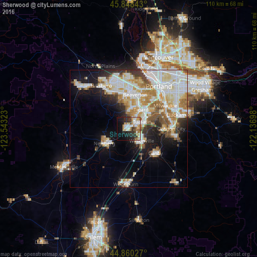
Analysis of Sherwood night lights 2016
Square area 10x10 km:
 10.48%
90-99
9.21%80-89
2.54%70-79
10%60-69
5.56%50-59
2.86%40-49
2.38%30-39
8.41%20-29
12.7%10-19
18.89%0-9
16.98%Square area 50x50 km:
8.92%90-99
8.84%80-89
4.08%70-79
4.09%60-69
3.88%50-59
3%40-49
2.35%30-39
2.58%20-29
3.98%10-19
10.5%0-9
47.77%Clear (daylight) street map image can be seen on geolist.org.
Map coordinates:
45° 50' 54.3" North, 123° 32' 35.6" West
45° 21' 23.4" North, 122° 50' 24.4" West
44° 51' 37" North, 122° 8' 13.1" West
Some cities around Sherwood sort by population:
• Beaverton
14.8 km =9.2 mi,  11°
11°
• Tigard
9.9 km =6.2 mi,  32°
32°
• Lake Oswego
15 km =9.3 mi,  61°
61°
• Tualatin
6.7 km =4.2 mi, 62°
• Newberg
12.1 km =7.5 mi,  238°
238°
• Wilsonville
8.2 km =5.1 mi,  140°
140°
• Garden Home-Whitford
13.5 km =8.4 mi, 27°
• Raleigh Hills
15.1 km =9.4 mi,  23°
23°
5751632 (p: 19,283)
Sources (retrieved 2019-11-25):
» Earth at Night: Flat Maps 2012, 2016