San Fernando night lights from space
Night Light of San Fernando (California) from space (United States) Src. Average luminocity for 10x10km area is 90.196% and for 50x50km: 52.1426%.

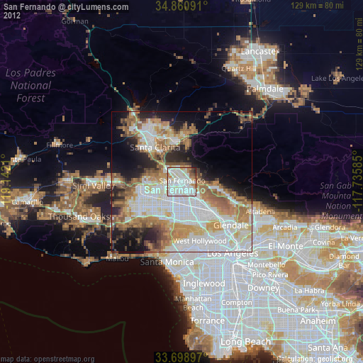
Analysis of San Fernando night lights 2016
Square area 10x10 km:
 33.33%
90-99
37.36%80-89
11.17%70-79
5.68%60-69
5.68%50-59
3.66%40-49
2.01%30-39
1.1%20-29
0%10-19
0%0-9
0%Square area 50x50 km:
15.17%90-99
11.62%80-89
5.22%70-79
6.56%60-69
9.48%50-59
5.93%40-49
4.89%30-39
4.95%20-29
6.13%10-19
8.43%0-9
21.64%Clear (daylight) street map image can be seen on geolist.org.
Map coordinates:
34° 51' 39.3" North, 119° 8' 31.6" West
34° 16' 55" North, 118° 26' 20.3" West
33° 41' 56.3" North, 117° 44' 9.1" West
Some cities around San Fernando sort by population:
• Van Nuys
10.6 km =6.6 mi,  184°
184°
• North Hollywood
13.4 km =8.3 mi,  155°
155°
• Northridge
10.8 km =6.7 mi,  236°
236°
• Valley Glen
10.3 km =6.4 mi,  185°
185°
• North Hills
6.6 km =4.1 mi,  219°
219°
• Tujunga
14.2 km =8.8 mi,  103°
103°
• Sunland
12.7 km =7.9 mi, 97°
• Shadow Hills
8.3 km =5.2 mi,  105°
105°
5391945 (p: 24,931)
Sources (retrieved 2019-11-25):
» Earth at Night: Flat Maps 2012, 2016