Scottsburg night lights from space
Night Light of Scottsburg (Indiana) from space (United States) Src. Average luminocity for 10x10km area is 24.7976% and for 50x50km: 3.3576%.
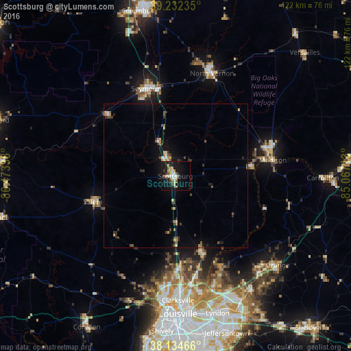
Analysis of Scottsburg night lights 2016
Square area 10x10 km:
 2.89%
2.89%90-99
3.74%80-89
5.44%70-79
1.87%60-69
1.02%50-59
4.76%40-49
1.87%30-39
2.72%20-29
4.08%10-19
34.52%0-9
37.07%Square area 50x50 km:
0.18%90-99
0.33%80-89
0.56%70-79
0.33%60-69
0.24%50-59
0.6%40-49
0.49%30-39
0.74%20-29
0.64%10-19
2.62%0-9
93.27%Clear (daylight) street map image can be seen on geolist.org.
Map coordinates:
39° 13' 56.5" North, 86° 28' 24.2" West
38° 41' 8.2" North, 85° 46' 12.9" West
38° 8' 4.8" North, 85° 4' 1.7" West
Some cities around Scottsburg sort by population:
• Seymour
32.1 km =19.9 mi,  341°
341°
• North Madison
33.7 km =20.9 mi,  74°
74°
• Madison
34.3 km =21.3 mi,  80°
80°
• Sellersburg
32 km =19.9 mi,  177°
177°
• Charlestown
27.3 km =17 mi,  161°
161°
• North Vernon
37.8 km =23.5 mi,  19°
19°
• Salem
30.1 km =18.7 mi,  252°
252°
• Oak Park
42.7 km =26.5 mi,  171°
171°
4264555 (p: 6,674)
Sources (retrieved 2019-11-25):
» Earth at Night: Flat Maps 2012, 2016