Seabrook night lights from space
Night Light of Seabrook (Maryland) from space (United States) Src. Average luminocity for 10x10km area is 89.375% and for 50x50km: 71.7843%.
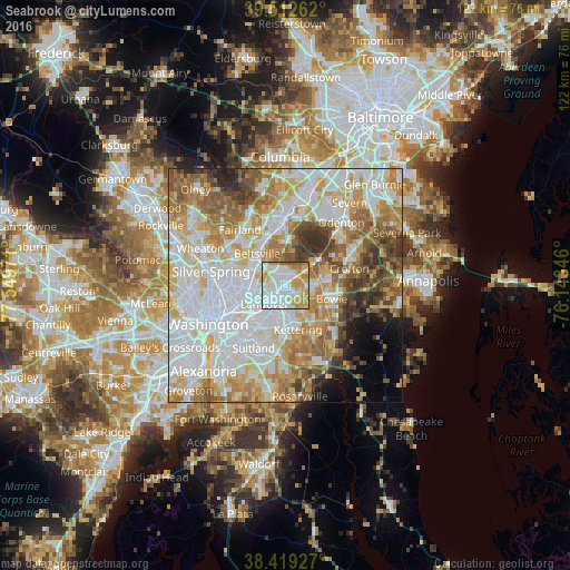
Analysis of Seabrook night lights 2016
Square area 10x10 km:
 36.36%
90-99
25%80-89
11.69%70-79
17.53%60-69
6.17%50-59
3.25%40-49
0%30-39
0%20-29
0%10-19
0%0-9
0%Square area 50x50 km:
22.5%90-99
17.5%80-89
10.21%70-79
10.91%60-69
9.48%50-59
7.74%40-49
5.11%30-39
4.47%20-29
2.9%10-19
2.87%0-9
6.31%Clear (daylight) street map image can be seen on geolist.org.
Map coordinates:
39° 30' 45.4" North, 77° 32' 59" West
38° 58' 5" North, 76° 50' 47.7" West
38° 25' 9.4" North, 76° 8' 36.5" West
Some cities around Seabrook sort by population:
• Greenbelt
4.8 km =3 mi,  328°
328°
• Lanham-Seabrook
0.4 km =0.2 mi,  274°
274°
• Glenn Dale
3.1 km =1.9 mi,  45°
45°
• New Carrollton
2.9 km =1.8 mi, 273°
• Lanham
1.5 km =0.9 mi, 273°
• Woodlawn
4.4 km =2.7 mi,  242°
242°
• Glenarden
4.5 km =2.8 mi,  196°
196°
• Goddard
2.5 km =1.6 mi,  346°
346°
4369076 (p: 17,287)
Sources (retrieved 2019-11-25):
» Earth at Night: Flat Maps 2012, 2016