Lanham-Seabrook night lights from space
Night Light of Lanham-Seabrook (Maryland) from space (United States) Src. Average luminocity for 10x10km area is 89.9756% and for 50x50km: 72.056%.
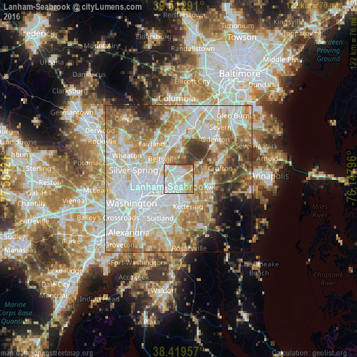
Analysis of Lanham-Seabrook night lights 2016
Square area 10x10 km:
 38.47%
90-99
25.16%80-89
11.36%70-79
16.4%60-69
5.36%50-59
3.25%40-49
0%30-39
0%20-29
0%10-19
0%0-9
0%Square area 50x50 km:
22.64%90-99
17.61%80-89
10.3%70-79
11.01%60-69
9.39%50-59
7.7%40-49
5.12%30-39
4.39%20-29
2.88%10-19
2.81%0-9
6.14%Clear (daylight) street map image can be seen on geolist.org.
Map coordinates:
39° 30' 46.5" North, 77° 33' 15.2" West
38° 58' 6.1" North, 76° 51' 3.9" West
38° 25' 10.5" North, 76° 8' 52.7" West
Some cities around Lanham-Seabrook sort by population:
• Greenbelt
4.5 km =2.8 mi,  332°
332°
• Landover
5.5 km =3.4 mi,  225°
225°
• Seabrook
0.4 km =0.2 mi,  94°
94°
• Glenn Dale
3.4 km =2.1 mi,  50°
50°
• New Carrollton
2.5 km =1.6 mi,  273°
273°
• Woodlawn
4.1 km =2.5 mi,  239°
239°
• Glenarden
4.4 km =2.7 mi,  191°
191°
• Goddard
2.4 km =1.5 mi,  355°
355°
7258832 (p: 18,190)
Sources (retrieved 2019-11-25):
» Earth at Night: Flat Maps 2012, 2016