New Carrollton night lights from space
Night Light of New Carrollton (Maryland) from space (United States) Src. Average luminocity for 10x10km area is 95.1429% and for 50x50km: 74.127%.
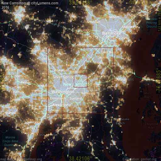
Analysis of New Carrollton night lights 2016
Square area 10x10 km:
 56.17%
90-99
28.08%80-89
5.52%70-79
6.33%60-69
1.14%50-59
2.76%40-49
0%30-39
0%20-29
0%10-19
0%0-9
0%Square area 50x50 km:
23.68%90-99
18.73%80-89
10.7%70-79
11.45%60-69
9.27%50-59
7.29%40-49
4.73%30-39
4.14%20-29
2.79%10-19
2.44%0-9
4.79%Clear (daylight) street map image can be seen on geolist.org.
Map coordinates:
39° 30' 51.8" North, 77° 34' 59.2" West
38° 58' 11.4" North, 76° 52' 47.9" West
38° 25' 15.8" North, 76° 10' 36.7" West
Some cities around New Carrollton sort by population:
• Greenbelt
3.9 km =2.4 mi,  5°
5°
• Landover
4.2 km =2.6 mi,  199°
199°
• Lanham-Seabrook
2.5 km =1.6 mi,  93°
93°
• Seabrook
2.9 km =1.8 mi, 93°
• East Riverdale
3.7 km =2.3 mi,  256°
256°
• Lanham
1.4 km =0.9 mi, 94°
• Woodlawn
2.5 km =1.6 mi, 203°
• Goddard
3.2 km =2 mi,  46°
46°
4363611 (p: 12,786)
Sources (retrieved 2019-11-25):
» Earth at Night: Flat Maps 2012, 2016