Woodlawn night lights from space
Night Light of Woodlawn (Maryland) from space (United States) Src. Average luminocity for 10x10km area is 98.1039% and for 50x50km: 74.3323%.
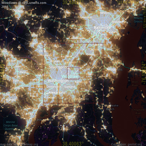
Analysis of Woodlawn night lights 2016
Square area 10x10 km:
 70.62%
90-99
22.4%80-89
4.55%70-79
2.44%60-69
0%50-59
0%40-49
0%30-39
0%20-29
0%10-19
0%0-9
0%Square area 50x50 km:
23.6%90-99
18.5%80-89
10.94%70-79
12.12%60-69
9.55%50-59
7.33%40-49
4.22%30-39
3.87%20-29
2.45%10-19
2.39%0-9
5.05%Clear (daylight) street map image can be seen on geolist.org.
Map coordinates:
39° 29' 39.4" North, 77° 35' 40.2" West
38° 56' 58.4" North, 76° 53' 28.9" West
38° 24' 2.3" North, 76° 11' 17.7" West
Some cities around Woodlawn sort by population:
• Landover
1.8 km =1.1 mi,  194°
194°
• East Riverdale
3 km =1.9 mi,  297°
297°
• New Carrollton
2.5 km =1.6 mi,  23°
23°
• Lanham
3.2 km =2 mi,  48°
48°
• Bladensburg
3.8 km =2.4 mi,  252°
252°
• Riverdale Park
3.8 km =2.4 mi,  293°
293°
• Cheverly
3.2 km =2 mi,  221°
221°
• Glenarden
3.4 km =2.1 mi,  131°
131°
4374056 (p: 6,334)
Sources (retrieved 2019-11-25):
» Earth at Night: Flat Maps 2012, 2016