Scotts Valley night lights from space
Night Light of Scotts Valley (California) from space (United States) Src. Average luminocity for 10x10km area is 14.1446% and for 50x50km: 10.1651%.
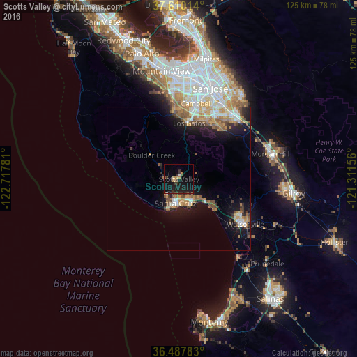
Analysis of Scotts Valley night lights 2016
Square area 10x10 km:
 0.34%
0.34%90-99
0.34%80-89
2.04%70-79
2.21%60-69
0.51%50-59
0.68%40-49
1.36%30-39
4.42%20-29
3.74%10-19
31.12%0-9
53.23%Square area 50x50 km:
1.01%90-99
1.59%80-89
0.76%70-79
1.97%60-69
2.01%50-59
1.6%40-49
1.53%30-39
1.15%20-29
1.81%10-19
7.63%0-9
78.93%Clear (daylight) street map image can be seen on geolist.org.
Map coordinates:
37° 36' 36.5" North, 122° 43' 4.1" West
37° 3' 3.8" North, 122° 0' 52.8" West
36° 29' 16.2" North, 121° 18' 41.6" West
Some cities around Scotts Valley sort by population:
• Santa Cruz
8.7 km =5.4 mi,  189°
189°
• Los Gatos
19.8 km =12.3 mi,  10°
10°
• Live Oak
8.1 km =5 mi,  157°
157°
• Capitola
10 km =6.2 mi,  147°
147°
• Soquel
8.7 km =5.4 mi,  143°
143°
• Rio Del Mar
13.7 km =8.5 mi,  132°
132°
• Ben Lomond
7.6 km =4.7 mi,  303°
303°
• Aptos
13.1 km =8.1 mi, 128°
5393971 (p: 11,945)
Sources (retrieved 2019-11-25):
» Earth at Night: Flat Maps 2012, 2016