Aptos night lights from space
Night Light of Aptos (California) from space (United States) Src. Average luminocity for 10x10km area is 17.2646% and for 50x50km: 7.7565%.
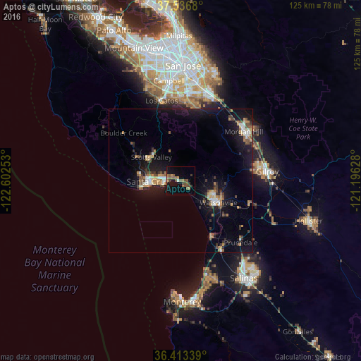
Analysis of Aptos night lights 2016
Square area 10x10 km:
 0.16%
0.16%90-99
1.14%80-89
0%70-79
2.76%60-69
4.38%50-59
5.52%40-49
4.38%30-39
2.44%20-29
0.32%10-19
19.32%0-9
59.58%Square area 50x50 km:
0.6%90-99
0.87%80-89
0.4%70-79
1.28%60-69
1.24%50-59
1%40-49
1.15%30-39
1.45%20-29
1.1%10-19
9.17%0-9
81.73%Clear (daylight) street map image can be seen on geolist.org.
Map coordinates:
37° 32' 12.5" North, 122° 36' 9.1" West
36° 58' 37.8" North, 121° 53' 57.8" West
36° 24' 48.2" North, 121° 11' 46.6" West
Some cities around Aptos sort by population:
• Santa Cruz
11.7 km =7.3 mi,  268°
268°
• Watsonville
14.7 km =9.1 mi,  120°
120°
• Live Oak
7.2 km =4.5 mi,  275°
275°
• Scotts Valley
13.1 km =8.1 mi,  308°
308°
• Capitola
4.8 km =3 mi, 267°
• Soquel
5.2 km =3.2 mi, 283°
• Rio Del Mar
1 km =0.6 mi,  184°
184°
• Interlaken
15 km =9.3 mi,  101°
101°
5324400 (p: 6,220)
Sources (retrieved 2019-11-25):
» Earth at Night: Flat Maps 2012, 2016