Scituate night lights from space
Night Light of Scituate (Massachusetts) from space (United States) Src. Average luminocity for 10x10km area is 15.7197% and for 50x50km: 19.4448%.
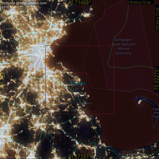
Analysis of Scituate night lights 2016
Square area 10x10 km:
 0.45%
0.45%90-99
0.15%80-89
0.3%70-79
0.91%60-69
3.79%50-59
2.88%40-49
6.82%30-39
4.24%20-29
7.27%10-19
17.12%0-9
56.06%Square area 50x50 km:
2.84%90-99
3.16%80-89
2.08%70-79
2.11%60-69
3.49%50-59
4.06%40-49
3.65%30-39
2.92%20-29
5.16%10-19
9.8%0-9
60.73%Clear (daylight) street map image can be seen on geolist.org.
Map coordinates:
42° 42' 52.9" North, 71° 25' 44.4" West
42° 11' 45.3" North, 70° 43' 33.1" West
41° 40' 22.3" North, 70° 1' 21.9" West
Some cities around Scituate sort by population:
• Weymouth
17.8 km =11.1 mi,  278°
278°
• Rockland
17.3 km =10.7 mi,  245°
245°
• Hanover
11.6 km =7.2 mi,  217°
217°
• Norwell
6.8 km =4.2 mi,  235°
235°
• Hull
19.1 km =11.9 mi,  308°
308°
• Cohasset
8.2 km =5.1 mi, 308°
• Hingham
14.4 km =8.9 mi,  290°
290°
• North Scituate
5.5 km =3.4 mi,  297°
297°
4950395 (p: 5,245)
Sources (retrieved 2019-11-25):
» Earth at Night: Flat Maps 2012, 2016