Hingham night lights from space
Night Light of Hingham (Massachusetts) from space (United States) Src. Average luminocity for 10x10km area is 48.9712% and for 50x50km: 39.5398%.
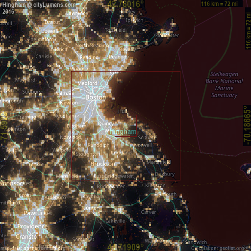
Analysis of Hingham night lights 2016
Square area 10x10 km:
 4.09%
4.09%90-99
5.15%80-89
8.48%70-79
5.76%60-69
10.45%50-59
15.3%40-49
10%30-39
5.3%20-29
21.21%10-19
13.94%0-9
0.3%Square area 50x50 km:
10.73%90-99
8.16%80-89
4.17%70-79
4.44%60-69
6.2%50-59
6.08%40-49
4.97%30-39
3.67%20-29
6.18%10-19
9.65%0-9
35.76%Clear (daylight) street map image can be seen on geolist.org.
Map coordinates:
42° 45' 36.6" North, 71° 35' 34.4" West
42° 14' 30.4" North, 70° 53' 23.2" West
41° 43' 8.7" North, 70° 11' 11.9" West
Some cities around Hingham sort by population:
• Quincy
9.3 km =5.8 mi,  277°
277°
• Weymouth
4.7 km =2.9 mi,  240°
240°
• Braintree
10.2 km =6.3 mi,  245°
245°
• Rockland
12.5 km =7.8 mi,  189°
189°
• Norwell
11.9 km =7.4 mi,  138°
138°
• Hull
6.9 km =4.3 mi,  347°
347°
• Cohasset
7.1 km =4.4 mi,  90°
90°
• North Scituate
8.9 km =5.5 mi,  106°
106°
4939549 (p: 5,650)
Sources (retrieved 2019-11-25):
» Earth at Night: Flat Maps 2012, 2016