Cohasset night lights from space
Night Light of Cohasset (Massachusetts) from space (United States) Src. Average luminocity for 10x10km area is 25.1712% and for 50x50km: 29.8389%.
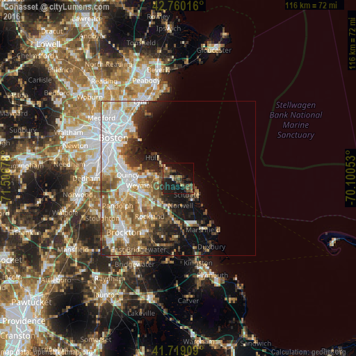
Analysis of Cohasset night lights 2016
Square area 10x10 km:
 0.91%
0.91%90-99
0.91%80-89
2.12%70-79
0.61%60-69
4.24%50-59
6.06%40-49
10.45%30-39
6.06%20-29
12.58%10-19
30.3%0-9
25.76%Square area 50x50 km:
7.65%90-99
5.96%80-89
3.01%70-79
3.09%60-69
4.73%50-59
5.06%40-49
4.12%30-39
3.08%20-29
5.04%10-19
8.8%0-9
49.45%Clear (daylight) street map image can be seen on geolist.org.
Map coordinates:
42° 45' 36.6" North, 71° 30' 24.4" West
42° 14' 30.4" North, 70° 48' 13.1" West
41° 43' 8.7" North, 70° 6' 1.9" West
Some cities around Cohasset sort by population:
• Weymouth
11.4 km =7.1 mi,  258°
258°
• Rockland
15.4 km =9.6 mi,  216°
216°
• Hanover
14.3 km =8.9 mi,  182°
182°
• Norwell
8.9 km =5.5 mi,  174°
174°
• Hull
10.9 km =6.8 mi,  308°
308°
• Hingham
7.1 km =4.4 mi,  270°
270°
• Scituate
8.2 km =5.1 mi,  128°
128°
• North Scituate
2.9 km =1.8 mi,  149°
149°
4933533 (p: 7,388)
Sources (retrieved 2019-11-25):
» Earth at Night: Flat Maps 2012, 2016