Saint Simon Mills night lights from space
Night Light of Saint Simon Mills (Georgia) from space (United States) Src. Average luminocity for 10x10km area is 32.5256% and for 50x50km: 8.9849%.
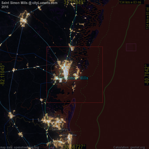
Analysis of Saint Simon Mills night lights 2016
Square area 10x10 km:
 0.37%
0.37%90-99
2.2%80-89
1.65%70-79
8.97%60-69
8.97%50-59
2.2%40-49
4.95%30-39
4.95%20-29
19.05%10-19
42.86%0-9
3.85%Square area 50x50 km:
1.14%90-99
1.21%80-89
0.42%70-79
1.6%60-69
1.78%50-59
0.86%40-49
1.52%30-39
1.85%20-29
2.68%10-19
6.23%0-9
80.71%Clear (daylight) street map image can be seen on geolist.org.
Map coordinates:
31° 46' 13.8" North, 82° 6' 37.6" West
31° 10' 14.8" North, 81° 24' 26.4" West
30° 34' 2.2" North, 80° 42' 15.1" West
Some cities around Saint Simon Mills sort by population:
• St. Marys
50.7 km =31.5 mi,  195°
195°
• Kingsland
49.2 km =30.6 mi,  213°
213°
• Brunswick
8.3 km =5.2 mi,  253°
253°
• Fernandina Beach
56 km =34.8 mi,  185°
185°
• Yulee
62.9 km =39.1 mi, 197°
• Jesup
66.5 km =41.3 mi,  316°
316°
• Country Club Estates
7.1 km =4.4 mi,  310°
310°
• Dock Junction
11 km =6.8 mi,  288°
288°
4220861 (p: 13,915)
Sources (retrieved 2019-11-25):
» Earth at Night: Flat Maps 2012, 2016