Country Club Estates night lights from space
Night Light of Country Club Estates (Georgia) from space (United States) Src. Average luminocity for 10x10km area is 59.6996% and for 50x50km: 9.2474%.
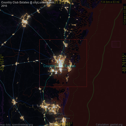
Analysis of Country Club Estates night lights 2016
Square area 10x10 km:
 15.02%
90-99
16.12%80-89
7.33%70-79
9.34%60-69
7.51%50-59
1.83%40-49
3.85%30-39
3.48%20-29
17.58%10-19
17.95%0-9
0%Square area 50x50 km:
1.15%90-99
1.22%80-89
0.42%70-79
1.69%60-69
1.78%50-59
0.92%40-49
1.52%30-39
1.94%20-29
2.76%10-19
6.29%0-9
80.3%Clear (daylight) street map image can be seen on geolist.org.
Map coordinates:
31° 48' 43.8" North, 82° 10' 2.6" West
31° 12' 45.8" North, 81° 27' 51.4" West
30° 36' 34.1" North, 80° 45' 40.1" West
Some cities around Country Club Estates sort by population:
• St. Marys
54.2 km =33.7 mi,  188°
188°
• Kingsland
50.7 km =31.5 mi,  205°
205°
• Brunswick
7.4 km =4.6 mi,  200°
200°
• Saint Simon Mills
7.1 km =4.4 mi,  130°
130°
• Saint Simons Island
11.4 km =7.1 mi, 127°
• Fernandina Beach
60.4 km =37.5 mi,  179°
179°
• Jesup
59.5 km =37 mi,  317°
317°
• Dock Junction
5.1 km =3.2 mi,  257°
257°
4189613 (p: 8,545)
Sources (retrieved 2019-11-25):
» Earth at Night: Flat Maps 2012, 2016