Saint Francis night lights from space
Night Light of Saint Francis (Wisconsin) from space (United States) Src. Average luminocity for 10x10km area is 71.1302% and for 50x50km: 35.5983%.
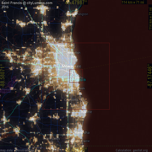
Analysis of Saint Francis night lights 2016
Square area 10x10 km:
 43.17%
90-99
16.51%80-89
2.06%70-79
2.22%60-69
1.11%50-59
0.32%40-49
1.75%30-39
6.19%20-29
10.95%10-19
12.22%0-9
3.49%Square area 50x50 km:
13.22%90-99
6.87%80-89
2.67%70-79
3.61%60-69
4.95%50-59
4.53%40-49
3.32%30-39
3.13%20-29
5.31%10-19
6.04%0-9
46.36%Clear (daylight) street map image can be seen on geolist.org.
Map coordinates:
43° 28' 47.5" North, 88° 34' 50.6" West
42° 58' 3.1" North, 87° 52' 39.3" West
42° 27' 3.1" North, 87° 10' 28.1" West
Some cities around Saint Francis sort by population:
• Milwaukee
8.3 km =5.2 mi,  343°
343°
• West Allis
11.9 km =7.4 mi,  297°
297°
• Greenfield
11 km =6.8 mi,  266°
266°
• Oak Creek
9.2 km =5.7 mi,  172°
172°
• South Milwaukee
6.5 km =4 mi, 167°
• Cudahy
1.6 km =1 mi,  123°
123°
• Greendale
10.1 km =6.3 mi,  252°
252°
• Shorewood
13.6 km =8.5 mi,  356°
356°
5270249 (p: 9,365)
Sources (retrieved 2019-11-25):
» Earth at Night: Flat Maps 2012, 2016