Safford night lights from space
Night Light of Safford (Arizona) from space (United States) Src. Average luminocity for 10x10km area is 22.3811% and for 50x50km: 1.9004%.
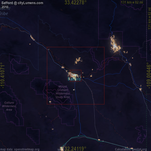
Analysis of Safford night lights 2016
Square area 10x10 km:
 1.4%
1.4%90-99
2.8%80-89
0.7%70-79
3.5%60-69
6.82%50-59
5.07%40-49
2.97%30-39
3.32%20-29
2.62%10-19
19.06%0-9
51.75%Square area 50x50 km:
0.07%90-99
0.14%80-89
0.05%70-79
0.28%60-69
0.67%50-59
0.32%40-49
0.33%30-39
0.43%20-29
0.31%10-19
0.98%0-9
96.43%Clear (daylight) street map image can be seen on geolist.org.
Map coordinates:
33° 25' 22" North, 110° 24' 38.6" West
32° 50' 2.2" North, 109° 42' 27.3" West
32° 14' 28.3" North, 109° 0' 16.1" West
Some cities around Safford sort by population:
• Tucson
133 km =82.6 mi,  239°
239°
• Catalina Foothills
128.2 km =79.7 mi, 242°
• Oro Valley
127.8 km =79.4 mi,  247°
247°
• Tanque Verde
116.2 km =72.2 mi, 236°
• Vail
128.5 km =79.8 mi,  227°
227°
• Saddle Brooke
114.1 km =70.9 mi, 253°
• Catalina
119.3 km =74.1 mi, 252°
• Globe
118.2 km =73.4 mi,  301°
301°
5312476 (p: 9,683)
Sources (retrieved 2019-11-25):
» Earth at Night: Flat Maps 2012, 2016