Vail night lights from space
Night Light of Vail (Arizona) from space (United States) Src. Average luminocity for 10x10km area is 10.278% and for 50x50km: 16.5451%.
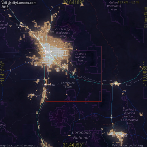
Analysis of Vail night lights 2016
Square area 10x10 km:
 0%
0%90-99
0%80-89
0%70-79
1.92%60-69
4.02%50-59
0%40-49
2.62%30-39
3.67%20-29
1.57%10-19
8.57%0-9
77.62%Square area 50x50 km:
4.03%90-99
3.78%80-89
1.09%70-79
2.5%60-69
3.18%50-59
1.75%40-49
1.77%30-39
2.13%20-29
1.77%10-19
4.4%0-9
73.59%Clear (daylight) street map image can be seen on geolist.org.
Map coordinates:
32° 38' 30.8" North, 111° 24' 54.6" West
32° 2' 52.3" North, 110° 42' 43.3" West
31° 26' 59.8" North, 110° 0' 32.1" West
Some cities around Vail sort by population:
• Tucson
28 km =17.4 mi,  313°
313°
• Catalina Foothills
33.9 km =21.1 mi,  325°
325°
• Drexel Heights
31.6 km =19.6 mi,  289°
289°
• Sahuarita
25.1 km =15.6 mi,  246°
246°
• Tanque Verde
22.8 km =14.2 mi,  354°
354°
• South Tucson
29.4 km =18.3 mi,  304°
304°
• Corona de Tucson
11 km =6.8 mi,  213°
213°
• Summit
22.7 km =14.1 mi,  275°
275°
5319311 (p: 10,208)
Sources (retrieved 2019-11-25):
» Earth at Night: Flat Maps 2012, 2016