Tanque Verde night lights from space
Night Light of Tanque Verde (Arizona) from space (United States) Src. Average luminocity for 10x10km area is 31.9231% and for 50x50km: 24.3596%.
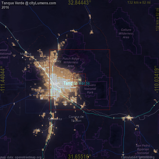
Analysis of Tanque Verde night lights 2016
Square area 10x10 km:
 0.18%
0.18%90-99
0.73%80-89
1.83%70-79
3.11%60-69
12.27%50-59
10.07%40-49
15.75%30-39
7.69%20-29
7.33%10-19
9.34%0-9
31.68%Square area 50x50 km:
4.98%90-99
4.65%80-89
1.53%70-79
4.27%60-69
7.06%50-59
3.48%40-49
2.25%30-39
2.39%20-29
3.02%10-19
6.54%0-9
59.83%Clear (daylight) street map image can be seen on geolist.org.
Map coordinates:
32° 50' 39.9" North, 111° 26' 25.6" West
32° 15' 6.3" North, 110° 44' 14.3" West
31° 39' 18.6" North, 110° 2' 3.1" West
Some cities around Tanque Verde sort by population:
• Tucson
18.1 km =11.2 mi,  259°
259°
• Casas Adobes
25.5 km =15.8 mi,  288°
288°
• Catalina Foothills
17.8 km =11.1 mi, 286°
• Oro Valley
26.5 km =16.5 mi,  305°
305°
• Flowing Wells
26 km =16.2 mi,  280°
280°
• Vail
22.8 km =14.2 mi,  174°
174°
• South Tucson
22.5 km =14 mi, 255°
• Summit
28.8 km =17.9 mi,  224°
224°
5316890 (p: 16,901)
Sources (retrieved 2019-11-25):
» Earth at Night: Flat Maps 2012, 2016