Rye Brook night lights from space
Night Light of Rye Brook (New York) from space (United States) Src. Average luminocity for 10x10km area is 70.8503% and for 50x50km: 51.2298%.
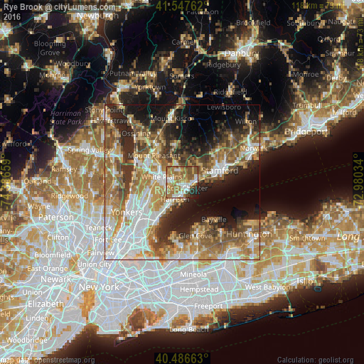
Analysis of Rye Brook night lights 2016
Square area 10x10 km:
 13.27%
90-99
14.63%80-89
8.16%70-79
9.69%60-69
26.87%50-59
13.78%40-49
5.1%30-39
1.7%20-29
5.78%10-19
1.02%0-9
0%Square area 50x50 km:
10.96%90-99
9.09%80-89
6.15%70-79
8.35%60-69
9.76%50-59
8.44%40-49
6.45%30-39
5.61%20-29
9.22%10-19
11.3%0-9
14.67%Clear (daylight) street map image can be seen on geolist.org.
Map coordinates:
41° 32' 51.4" North, 74° 23' 11.7" West
41° 1' 9.3" North, 73° 41' 0.5" West
40° 29' 11.9" North, 72° 58' 49.2" West
Some cities around Rye Brook sort by population:
• White Plains
6.9 km =4.3 mi,  283°
283°
• Port Chester
2.5 km =1.6 mi,  142°
142°
• Harrison
6.1 km =3.8 mi,  203°
203°
• Mamaroneck
8.9 km =5.5 mi,  207°
207°
• Scarsdale
8.6 km =5.3 mi,  259°
259°
• Rye
4.3 km =2.7 mi,  180°
180°
• Greenwich
4.7 km =2.9 mi,  80°
80°
• Cos Cob
7.2 km =4.5 mi, 77°
5134696 (p: 9,611)
Sources (retrieved 2019-11-25):
» Earth at Night: Flat Maps 2012, 2016