Royse City night lights from space
Night Light of Royse City (Texas) from space (United States) Src. Average luminocity for 10x10km area is 32.4341% and for 50x50km: 28.989%.
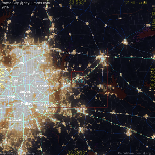
Analysis of Royse City night lights 2016
Square area 10x10 km:
 0.92%
0.92%90-99
0.55%80-89
7.51%70-79
2.75%60-69
4.76%50-59
8.42%40-49
6.41%30-39
10.07%20-29
10.62%10-19
42.49%0-9
5.49%Square area 50x50 km:
1.75%90-99
2.75%80-89
4.99%70-79
5.03%60-69
5.93%50-59
5.95%40-49
5.02%30-39
8.05%20-29
6.29%10-19
13.22%0-9
41.03%Clear (daylight) street map image can be seen on geolist.org.
Map coordinates:
33° 33' 46.8" North, 97° 2' 8.2" West
32° 58' 30.4" North, 96° 19' 56.9" West
32° 22' 59.9" North, 95° 37' 45.7" West
Some cities around Royse City sort by population:
• Rowlett
23 km =14.3 mi,  249°
249°
• Wylie
19.8 km =12.3 mi,  283°
283°
• Rockwall
12.8 km =8 mi, 247°
• Sachse
24.5 km =15.2 mi,  270°
270°
• Murphy
26.5 km =16.5 mi, 279°
• Fate
5.9 km =3.7 mi,  230°
230°
• Heath
20.4 km =12.7 mi,  220°
220°
• Lucas
25.8 km =16 mi,  298°
298°
4724241 (p: 11,465)
Sources (retrieved 2019-11-25):
» Earth at Night: Flat Maps 2012, 2016