Fate night lights from space
Night Light of Fate (Texas) from space (United States) Src. Average luminocity for 10x10km area is 49.3516% and for 50x50km: 36.3962%.
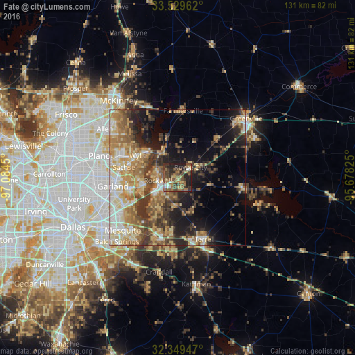
Analysis of Fate night lights 2016
Square area 10x10 km:
 3.48%
3.48%90-99
3.66%80-89
5.49%70-79
4.95%60-69
15.2%50-59
17.58%40-49
12.09%30-39
11.9%20-29
16.85%10-19
8.79%0-9
0%Square area 50x50 km:
4.15%90-99
5.37%80-89
6.73%70-79
5.96%60-69
7.35%50-59
5.98%40-49
4.56%30-39
7.91%20-29
6.26%10-19
11.9%0-9
33.83%Clear (daylight) street map image can be seen on geolist.org.
Map coordinates:
33° 31' 46.6" North, 97° 5' 4.2" West
32° 56' 29.4" North, 96° 22' 52.9" West
32° 20' 58.1" North, 95° 40' 41.7" West
Some cities around Fate sort by population:
• Rowlett
17.6 km =10.9 mi,  255°
255°
• Wylie
16.8 km =10.4 mi,  299°
299°
• Rockwall
7.4 km =4.6 mi, 261°
• Sachse
20.3 km =12.6 mi,  280°
280°
• Murphy
23.1 km =14.4 mi,  290°
290°
• Forney
23.1 km =14.4 mi,  201°
201°
• Royse City
5.9 km =3.7 mi,  50°
50°
• Heath
14.6 km =9.1 mi,  216°
216°
4690257 (p: 9,847)
Sources (retrieved 2019-11-25):
» Earth at Night: Flat Maps 2012, 2016