Roslyn Heights night lights from space
Night Light of Roslyn Heights (New York) from space (United States) Src. Average luminocity for 10x10km area is 89.5909% and for 50x50km: 67.4204%.
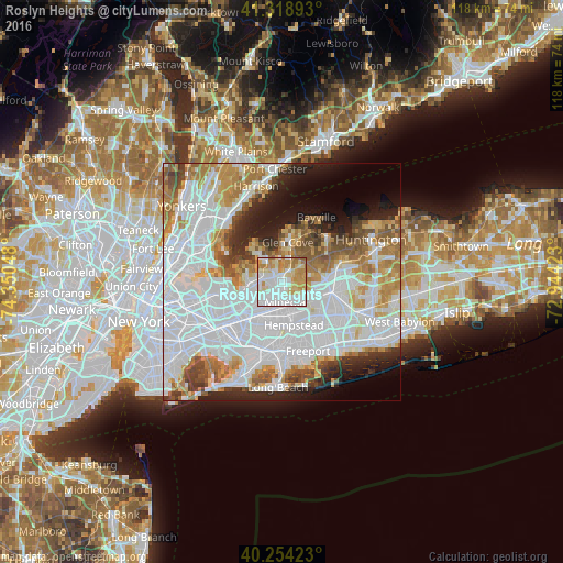
Analysis of Roslyn Heights night lights 2016
Square area 10x10 km:
 31.66%
90-99
28.57%80-89
14.94%70-79
15.1%60-69
8.44%50-59
1.3%40-49
0%30-39
0%20-29
0%10-19
0%0-9
0%Square area 50x50 km:
31.08%90-99
14.79%80-89
4.98%70-79
6.77%60-69
7.13%50-59
4.88%40-49
3.7%30-39
3.3%20-29
5.8%10-19
6.68%0-9
10.9%Clear (daylight) street map image can be seen on geolist.org.
Map coordinates:
41° 19' 8.1" North, 74° 21' 1.7" West
40° 47' 19.4" North, 73° 38' 50.5" West
40° 15' 15.2" North, 72° 56' 39.2" West
Some cities around Roslyn Heights sort by population:
• Mineola
4.4 km =2.7 mi,  172°
172°
• Port Washington
5.9 km =3.7 mi,  313°
313°
• Manhasset
4.5 km =2.8 mi,  283°
283°
• Garden City Park
5.5 km =3.4 mi,  193°
193°
• Williston Park
3.6 km =2.2 mi,  176°
176°
• East Hills
1.8 km =1.1 mi,  71°
71°
• North Hills
2.6 km =1.6 mi,  250°
250°
• Albertson
1.7 km =1.1 mi, 168°
5134420 (p: 6,577)
Sources (retrieved 2019-11-25):
» Earth at Night: Flat Maps 2012, 2016