Rosaryville night lights from space
Night Light of Rosaryville (Maryland) from space (United States) Src. Average luminocity for 10x10km area is 46.7738% and for 50x50km: 47.1366%.
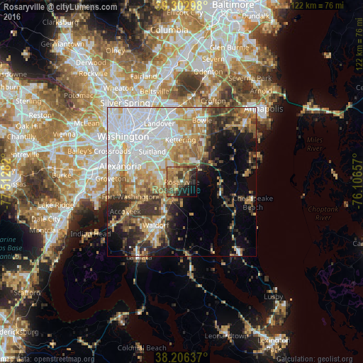
Analysis of Rosaryville night lights 2016
Square area 10x10 km:
 0.68%
0.68%90-99
0.68%80-89
10.37%70-79
11.9%60-69
11.22%50-59
15.14%40-49
10.71%30-39
8.33%20-29
10.03%10-19
13.95%0-9
6.97%Square area 50x50 km:
14.27%90-99
8.25%80-89
6.19%70-79
6.96%60-69
5.99%50-59
5.56%40-49
4.47%30-39
5.88%20-29
5.95%10-19
7.75%0-9
28.73%Clear (daylight) street map image can be seen on geolist.org.
Map coordinates:
39° 18' 10.7" North, 77° 30' 46.2" West
38° 45' 24.4" North, 76° 48' 34.9" West
38° 12' 22.9" North, 76° 6' 23.7" West
Some cities around Rosaryville sort by population:
• Clinton
7.7 km =4.8 mi,  276°
276°
• Camp Springs
9.9 km =6.2 mi,  301°
301°
• Greater Upper Marlboro
9.9 km =6.2 mi,  32°
32°
• Brock Hall
11.2 km =7 mi,  22°
22°
• Marlboro Village
8.9 km =5.5 mi, 22°
• Marlton
2.5 km =1.6 mi,  42°
42°
• Westphalia
9.9 km =6.2 mi,  359°
359°
• Brandywine
7.4 km =4.6 mi,  206°
206°
4367344 (p: 10,697)
Sources (retrieved 2019-11-25):
» Earth at Night: Flat Maps 2012, 2016