Brandywine night lights from space
Night Light of Brandywine (Maryland) from space (United States) Src. Average luminocity for 10x10km area is 42.9439% and for 50x50km: 39.4277%.
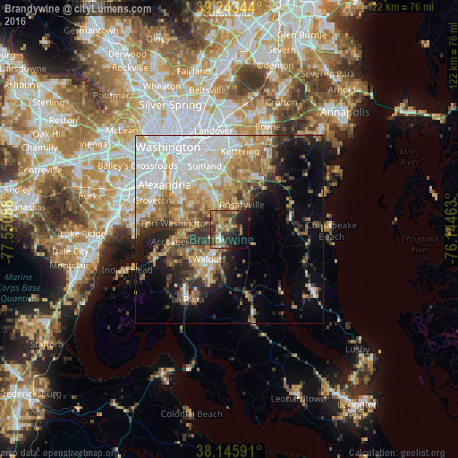
Analysis of Brandywine night lights 2016
Square area 10x10 km:
 2.55%
2.55%90-99
2.21%80-89
6.97%70-79
8.84%60-69
10.03%50-59
9.69%40-49
7.65%30-39
14.12%20-29
13.27%10-19
15.48%0-9
9.18%Square area 50x50 km:
10.27%90-99
6.91%80-89
5.59%70-79
5.76%60-69
5.55%50-59
4.92%40-49
3.79%30-39
4.83%20-29
5.74%10-19
8.74%0-9
37.9%Clear (daylight) street map image can be seen on geolist.org.
Map coordinates:
39° 14' 36.4" North, 77° 33' 3.2" West
38° 41' 48.4" North, 76° 50' 51.9" West
38° 8' 45.3" North, 76° 8' 40.7" West
Some cities around Brandywine sort by population:
• Waldorf
11.3 km =7 mi,  224°
224°
• Saint Charles
13.1 km =8.1 mi, 217°
• Clinton
8.8 km =5.5 mi,  330°
330°
• St. Charles
12 km =7.5 mi,  213°
213°
• Camp Springs
13 km =8.1 mi,  336°
336°
• Rosaryville
7.4 km =4.6 mi,  26°
26°
• Friendly
12.9 km =8 mi,  298°
298°
• Marlton
9.9 km =6.2 mi, 30°
4349283 (p: 6,719)
Sources (retrieved 2019-11-25):
» Earth at Night: Flat Maps 2012, 2016