Rockford night lights from space
Night Light of Rockford (Michigan) from space (United States) Src. Average luminocity for 10x10km area is 19.8061% and for 50x50km: 15.602%.
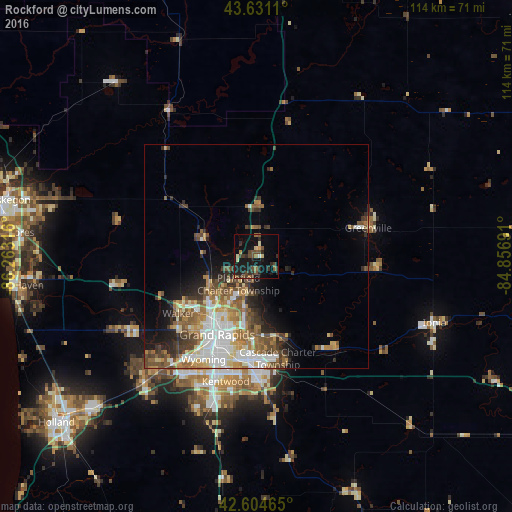
Analysis of Rockford night lights 2016
Square area 10x10 km:
 0%
0%90-99
1.21%80-89
2.88%70-79
1.36%60-69
2.42%50-59
2.73%40-49
6.97%30-39
4.09%20-29
8.03%10-19
22.27%0-9
48.03%Square area 50x50 km:
3.08%90-99
2.67%80-89
1.81%70-79
1.7%60-69
2.72%50-59
2.56%40-49
2.77%30-39
2.16%20-29
2.55%10-19
4.89%0-9
73.09%Clear (daylight) street map image can be seen on geolist.org.
Map coordinates:
43° 37' 52" North, 86° 15' 47.4" West
43° 7' 12.1" North, 85° 33' 36.1" West
42° 36' 16.7" North, 84° 51' 24.9" West
Some cities around Rockford sort by population:
• Grand Rapids
19.5 km =12.1 mi,  206°
206°
• Wyoming
25.8 km =16 mi, 207°
• Forest Hills
18.7 km =11.6 mi,  162°
162°
• Walker
21.4 km =13.3 mi,  232°
232°
• Northview
8.9 km =5.5 mi,  201°
201°
• East Grand Rapids
20.3 km =12.6 mi,  191°
191°
• Comstock Park
12.7 km =7.9 mi,  224°
224°
• Greenville
25.7 km =16 mi,  75°
75°
5007436 (p: 6,134)
Sources (retrieved 2019-11-25):
» Earth at Night: Flat Maps 2012, 2016