Comstock Park night lights from space
Night Light of Comstock Park (Michigan) from space (United States) Src. Average luminocity for 10x10km area is 60.819% and for 50x50km: 22.9269%.
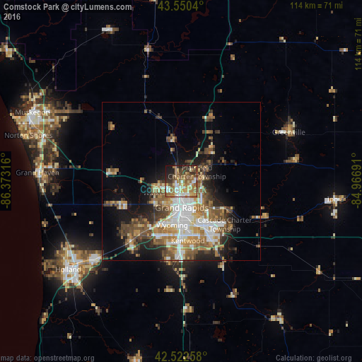
Analysis of Comstock Park night lights 2016
Square area 10x10 km:
 9.21%
9.21%90-99
9.84%80-89
9.37%70-79
9.52%60-69
17.14%50-59
11.43%40-49
9.84%30-39
6.67%20-29
10.16%10-19
6.67%0-9
0.16%Square area 50x50 km:
4.2%90-99
3.84%80-89
2.5%70-79
2.75%60-69
4.13%50-59
3.89%40-49
4.2%30-39
3.1%20-29
4.19%10-19
8.39%0-9
58.81%Clear (daylight) street map image can be seen on geolist.org.
Map coordinates:
43° 33' 1.4" North, 86° 22' 23.4" West
43° 2' 19.1" North, 85° 40' 12.1" West
42° 31' 21.3" North, 84° 58' 0.9" West
Some cities around Comstock Park sort by population:
• Grand Rapids
8.4 km =5.2 mi,  178°
178°
• Wyoming
14.2 km =8.8 mi,  191°
191°
• Forest Hills
17.1 km =10.6 mi,  120°
120°
• Walker
9 km =5.6 mi,  242°
242°
• Grandville
16.2 km =10.1 mi,  207°
207°
• Northview
5.7 km =3.5 mi,  82°
82°
• East Grand Rapids
11.9 km =7.4 mi,  155°
155°
• Rockford
12.7 km =7.9 mi,  44°
44°
4989432 (p: 10,088)
Sources (retrieved 2019-11-25):
» Earth at Night: Flat Maps 2012, 2016