Athol night lights from space
Night Light of Athol (Massachusetts) from space (United States) Src. Average luminocity for 10x10km area is 8.0455% and for 50x50km: 2.6835%.
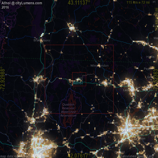
Analysis of Athol night lights 2016
Square area 10x10 km:
 0.45%
0.45%90-99
0.76%80-89
1.06%70-79
0.76%60-69
1.21%50-59
1.36%40-49
2.88%30-39
1.82%20-29
1.06%10-19
0.15%0-9
88.48%Square area 50x50 km:
0.15%90-99
0.3%80-89
0.25%70-79
0.27%60-69
0.46%50-59
0.42%40-49
0.63%30-39
0.58%20-29
0.65%10-19
1.06%0-9
95.22%Clear (daylight) street map image can be seen on geolist.org.
Map coordinates:
43° 6' 40.9" North, 72° 55' 47.6" West
42° 35' 45.3" North, 72° 13' 36.3" West
42° 4' 34.2" North, 71° 31' 25.1" West
Some cities around Athol sort by population:
• Gardner
18.9 km =11.7 mi,  97°
97°
• Greenfield
30.5 km =19 mi,  268°
268°
• Montague
26.1 km =16.2 mi,  255°
255°
• Swanzey
30.8 km =19.1 mi,  351°
351°
• Westminster
26.5 km =16.5 mi, 102°
• Templeton
13.8 km =8.6 mi,  108°
108°
• Rindge
24.8 km =15.4 mi,  45°
45°
• Ashburnham
26.5 km =16.5 mi,  80°
80°
4929376 (p: 8,265)
Sources (retrieved 2019-11-25):
» Earth at Night: Flat Maps 2012, 2016