Richboro night lights from space
Night Light of Richboro (Pennsylvania) from space (United States) Src. Average luminocity for 10x10km area is 53.7175% and for 50x50km: 59.0583%.
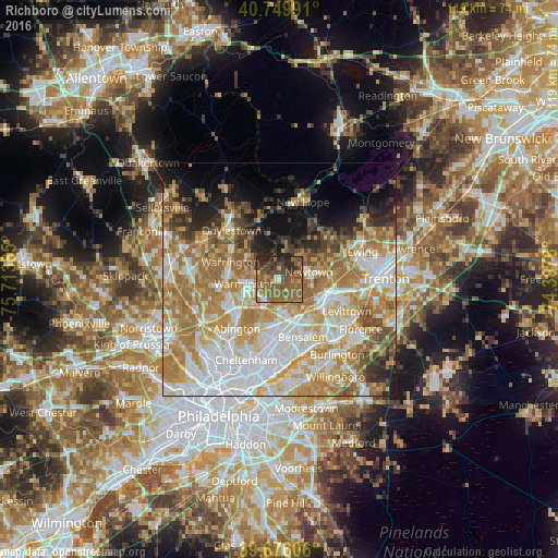
Analysis of Richboro night lights 2016
Square area 10x10 km:
 2.11%
2.11%90-99
3.41%80-89
3.57%70-79
5.84%60-69
16.23%50-59
32.14%40-49
16.72%30-39
7.79%20-29
11.36%10-19
0.81%0-9
0%Square area 50x50 km:
14.01%90-99
11.91%80-89
8.54%70-79
10.97%60-69
12.99%50-59
6.88%40-49
4.53%30-39
3.81%20-29
4.96%10-19
7.03%0-9
14.36%Clear (daylight) street map image can be seen on geolist.org.
Map coordinates:
40° 44' 59.7" North, 75° 42' 49.9" West
40° 12' 54.4" North, 75° 0' 38.6" West
39° 40' 33.8" North, 74° 18' 27.4" West
Some cities around Richboro sort by population:
• Levittown
16.8 km =10.4 mi,  113°
113°
• Willow Grove
11.9 km =7.4 mi,  228°
228°
• Horsham
10.8 km =6.7 mi,  247°
247°
• Fairless Hills
13.8 km =8.6 mi, 106°
• Doylestown
14.6 km =9.1 mi,  316°
316°
• Hatboro
9.3 km =5.8 mi,  240°
240°
• Maple Glen
15 km =9.3 mi, 254°
• Dresher
15.6 km =9.7 mi, 238°
5208166 (p: 6,563)
Sources (retrieved 2019-11-25):
» Earth at Night: Flat Maps 2012, 2016