Doylestown night lights from space
Night Light of Doylestown (Pennsylvania) from space (United States) Src. Average luminocity for 10x10km area is 50.6139% and for 50x50km: 43.0011%.
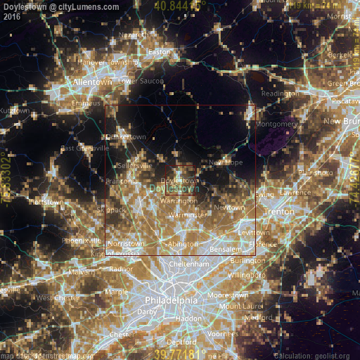
Analysis of Doylestown night lights 2016
Square area 10x10 km:
 3.57%
3.57%90-99
3.57%80-89
7.14%70-79
6.46%60-69
9.52%50-59
15.99%40-49
19.05%30-39
16.5%20-29
12.93%10-19
5.27%0-9
0%Square area 50x50 km:
6.29%90-99
7.21%80-89
6.32%70-79
8.17%60-69
11.1%50-59
7.18%40-49
5.02%30-39
4.77%20-29
5.49%10-19
10.25%0-9
28.2%Clear (daylight) street map image can be seen on geolist.org.
Map coordinates:
40° 50' 38.9" North, 75° 49' 58.9" West
40° 18' 36.4" North, 75° 7' 47.6" West
39° 46' 18.5" North, 74° 25' 36.4" West
Some cities around Doylestown sort by population:
• Lansdale
15.1 km =9.4 mi,  239°
239°
• Horsham
14.6 km =9.1 mi,  179°
179°
• Montgomeryville
11.9 km =7.4 mi,  234°
234°
• Perkasie
15.4 km =9.6 mi,  296°
296°
• Bedminster
13.5 km =8.4 mi,  342°
342°
• Hatboro
15.2 km =9.4 mi,  172°
172°
• Maple Glen
15.2 km =9.4 mi,  196°
196°
• Richboro
14.6 km =9.1 mi,  136°
136°
5187247 (p: 8,301)
Sources (retrieved 2019-11-25):
» Earth at Night: Flat Maps 2012, 2016