Dresher night lights from space
Night Light of Dresher (Pennsylvania) from space (United States) Src. Average luminocity for 10x10km area is 83.7143% and for 50x50km: 71.0133%.
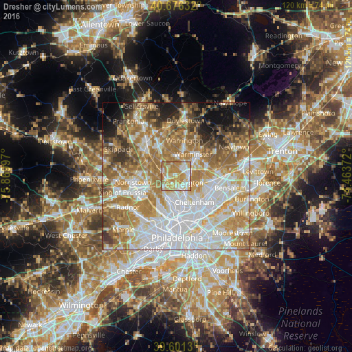
Analysis of Dresher night lights 2016
Square area 10x10 km:
 20.29%
90-99
18.02%80-89
17.21%70-79
27.27%60-69
17.21%50-59
0%40-49
0%30-39
0%20-29
0%10-19
0%0-9
0%Square area 50x50 km:
20.72%90-99
14.68%80-89
9.59%70-79
11.93%60-69
14.25%50-59
8.07%40-49
5.05%30-39
4.23%20-29
3.77%10-19
5%0-9
2.71%Clear (daylight) street map image can be seen on geolist.org.
Map coordinates:
40° 40' 34.8" North, 75° 52' 11.9" West
40° 8' 27.4" North, 75° 10' 0.6" West
39° 36' 4.7" North, 74° 27' 49.4" West
Some cities around Dresher sort by population:
• Willow Grove
4.4 km =2.7 mi,  85°
85°
• Horsham
5.3 km =3.3 mi,  37°
37°
• Glenside
4.5 km =2.8 mi,  163°
163°
• Hatboro
6.3 km =3.9 mi,  53°
53°
• Maple Glen
4.4 km =2.7 mi,  344°
344°
• Ambler
4.9 km =3 mi,  288°
288°
• Oreland
2.7 km =1.7 mi,  200°
200°
• Fort Washington
3.6 km =2.2 mi,  271°
271°
5187297 (p: 5,610)
Sources (retrieved 2019-11-25):
» Earth at Night: Flat Maps 2012, 2016