Willow Grove night lights from space
Night Light of Willow Grove (Pennsylvania) from space (United States) Src. Average luminocity for 10x10km area is 82.862% and for 50x50km: 71.767%.
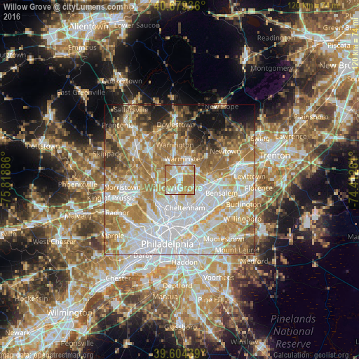
Analysis of Willow Grove night lights 2016
Square area 10x10 km:
 17.69%
90-99
19.16%80-89
15.75%70-79
28.41%60-69
18.67%50-59
0.32%40-49
0%30-39
0%20-29
0%10-19
0%0-9
0%Square area 50x50 km:
20.75%90-99
15.01%80-89
10.01%70-79
12.49%60-69
14.89%50-59
7.43%40-49
4.34%30-39
3.82%20-29
3.84%10-19
4.98%0-9
2.45%Clear (daylight) street map image can be seen on geolist.org.
Map coordinates:
40° 40' 45.7" North, 75° 49' 7.9" West
40° 8' 38.4" North, 75° 6' 56.6" West
39° 36' 15.8" North, 74° 24' 45.4" West
Some cities around Willow Grove sort by population:
• Horsham
4 km =2.5 mi,  344°
344°
• Glenside
5.6 km =3.5 mi,  213°
213°
• Hatboro
3.5 km =2.2 mi,  12°
12°
• Maple Glen
6.8 km =4.2 mi,  305°
305°
• Ambler
9.1 km =5.7 mi,  277°
277°
• Oreland
6 km =3.7 mi,  241°
241°
• Dresher
4.4 km =2.7 mi,  265°
265°
• Fort Washington
7.9 km =4.9 mi, 268°
5219619 (p: 15,726)
Sources (retrieved 2019-11-25):
» Earth at Night: Flat Maps 2012, 2016