Red Lion night lights from space
Night Light of Red Lion (Pennsylvania) from space (United States) Src. Average luminocity for 10x10km area is 36.4779% and for 50x50km: 21.9674%.
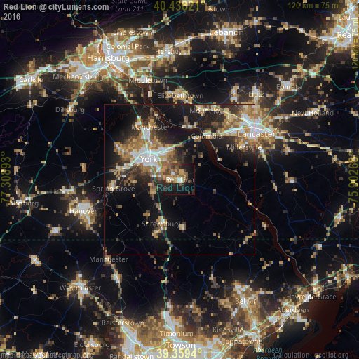
Analysis of Red Lion night lights 2016
Square area 10x10 km:
 2.04%
2.04%90-99
3.57%80-89
4.42%70-79
7.65%60-69
6.8%50-59
8.67%40-49
7.99%30-39
5.61%20-29
9.18%10-19
27.89%0-9
16.16%Square area 50x50 km:
2.83%90-99
2.83%80-89
2.77%70-79
3.11%60-69
4.23%50-59
3.4%40-49
3.16%30-39
3.54%20-29
5.98%10-19
14.61%0-9
53.52%Clear (daylight) street map image can be seen on geolist.org.
Map coordinates:
40° 26' 17.6" North, 77° 18' 32.1" West
39° 54' 3.3" North, 76° 36' 20.9" West
39° 21' 33.8" North, 75° 54' 9.6" West
Some cities around Red Lion sort by population:
• York
12.5 km =7.8 mi,  303°
303°
• Weigelstown
20.6 km =12.8 mi, 296°
• Elizabethtown
28 km =17.4 mi,  0°
0°
• Shiloh
18.4 km =11.4 mi, 297°
• Columbia
17.1 km =10.6 mi,  30°
30°
• East York
10.6 km =6.6 mi,  319°
319°
• Millersville
24 km =14.9 mi,  63°
63°
• Mount Joy
24.8 km =15.4 mi,  20°
20°
4560639 (p: 6,321)
Sources (retrieved 2019-11-25):
» Earth at Night: Flat Maps 2012, 2016