East York night lights from space
Night Light of East York (Pennsylvania) from space (United States) Src. Average luminocity for 10x10km area is 76.8861% and for 50x50km: 23.5288%.
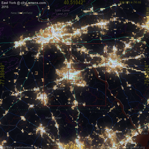
Analysis of East York night lights 2016
Square area 10x10 km:
 23.13%
90-99
18.2%80-89
8.84%70-79
10.2%60-69
18.88%50-59
9.01%40-49
5.78%30-39
1.36%20-29
4.25%10-19
0.34%0-9
0%Square area 50x50 km:
2.56%90-99
2.74%80-89
3%70-79
3.17%60-69
3.99%50-59
3.4%40-49
3.68%30-39
4.38%20-29
7.96%10-19
20.55%0-9
44.57%Clear (daylight) street map image can be seen on geolist.org.
Map coordinates:
40° 30' 37.5" North, 77° 23' 22.2" West
39° 58' 25.4" North, 76° 41' 10.9" West
39° 25' 57.9" North, 75° 58' 59.7" West
Some cities around East York sort by population:
• York
3.7 km =2.3 mi,  250°
250°
• Weigelstown
11.7 km =7.3 mi,  275°
275°
• Elizabethtown
21.2 km =13.2 mi,  19°
19°
• Shiloh
9.5 km =5.9 mi,  272°
272°
• Columbia
16.9 km =10.5 mi,  66°
66°
• Middletown
25.4 km =15.8 mi,  351°
351°
• Mount Joy
21.7 km =13.5 mi,  45°
45°
• Red Lion
10.6 km =6.6 mi,  139°
139°
4557717 (p: 8,777)
Sources (retrieved 2019-11-25):
» Earth at Night: Flat Maps 2012, 2016