Millersville night lights from space
Night Light of Millersville (Pennsylvania) from space (United States) Src. Average luminocity for 10x10km area is 40.5408% and for 50x50km: 21.8553%.
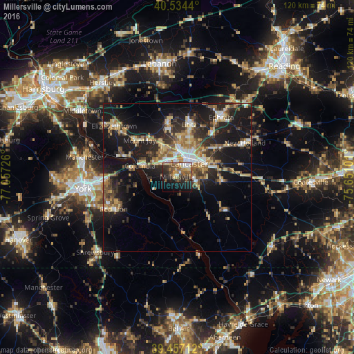
Analysis of Millersville night lights 2016
Square area 10x10 km:
 4.76%
4.76%90-99
3.91%80-89
6.29%70-79
5.95%60-69
7.31%50-59
9.18%40-49
6.97%30-39
6.12%20-29
13.95%10-19
21.94%0-9
13.61%Square area 50x50 km:
2.18%90-99
2.62%80-89
3.66%70-79
2.83%60-69
3.42%50-59
3.03%40-49
3.11%30-39
3.91%20-29
7.13%10-19
19.09%0-9
49.02%Clear (daylight) street map image can be seen on geolist.org.
Map coordinates:
40° 32' 3.8" North, 77° 3' 26.1" West
39° 59' 52.4" North, 76° 21' 14.9" West
39° 27' 25.6" North, 75° 39' 3.6" West
Some cities around Millersville sort by population:
• Lancaster
6.1 km =3.8 mi,  42°
42°
• Ephrata
25.1 km =15.6 mi, 36°
• Columbia
13.4 km =8.3 mi,  287°
287°
• Lititz
18.2 km =11.3 mi,  12°
12°
• Mount Joy
17.8 km =11.1 mi,  314°
314°
• Willow Street
6.9 km =4.3 mi,  107°
107°
• Leola
17.5 km =10.9 mi,  55°
55°
• Red Lion
24 km =14.9 mi,  243°
243°
4559685 (p: 8,420)
Sources (retrieved 2019-11-25):
» Earth at Night: Flat Maps 2012, 2016