Elizabethtown night lights from space
Night Light of Elizabethtown (Pennsylvania) from space (United States) Src. Average luminocity for 10x10km area is 32.8442% and for 50x50km: 36.615%.
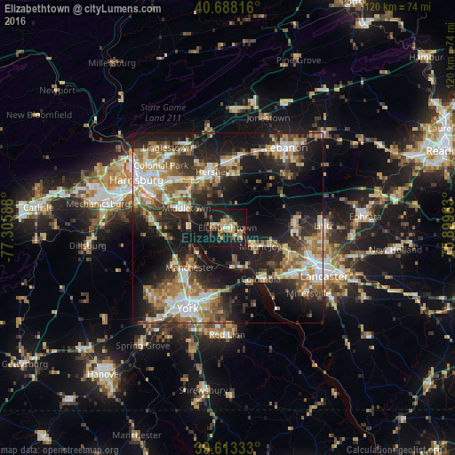
Analysis of Elizabethtown night lights 2016
Square area 10x10 km:
 1.46%
1.46%90-99
3.57%80-89
7.14%70-79
8.12%60-69
1.62%50-59
4.38%40-49
3.9%30-39
5.03%20-29
6.33%10-19
50%0-9
8.44%Square area 50x50 km:
5.41%90-99
5.74%80-89
5.06%70-79
4.91%60-69
5.96%50-59
5.49%40-49
5.07%30-39
5.76%20-29
10.22%10-19
23.59%0-9
22.79%Clear (daylight) street map image can be seen on geolist.org.
Map coordinates:
40° 41' 17.4" North, 77° 18' 21.2" West
40° 9' 10.3" North, 76° 36' 9.9" West
39° 36' 48" North, 75° 53' 58.7" West
Some cities around Elizabethtown sort by population:
• York
23.7 km =14.7 mi,  206°
206°
• Hershey
15.3 km =9.5 mi,  344°
344°
• Columbia
15.7 km =9.8 mi,  147°
147°
• Middletown
12.1 km =7.5 mi,  295°
295°
• East York
21.2 km =13.2 mi,  199°
199°
• Mount Joy
9.7 km =6 mi,  119°
119°
• Palmyra
17.4 km =10.8 mi,  2°
2°
• Steelton
22.2 km =13.8 mi,  294°
294°
5188474 (p: 11,586)
Sources (retrieved 2019-11-25):
» Earth at Night: Flat Maps 2012, 2016