Bridgewater night lights from space
Night Light of Bridgewater (Massachusetts) from space (United States) Src. Average luminocity for 10x10km area is 44.054% and for 50x50km: 35.467%.
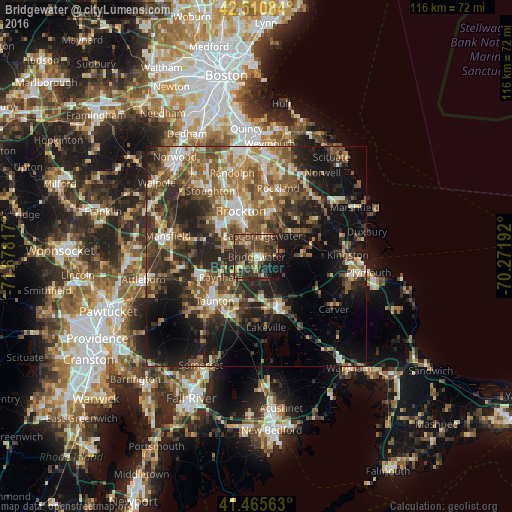
Analysis of Bridgewater night lights 2016
Square area 10x10 km:
 2.06%
2.06%90-99
3.33%80-89
7.14%70-79
4.76%60-69
4.76%50-59
10.32%40-49
18.25%30-39
18.57%20-29
18.41%10-19
11.9%0-9
0.48%Square area 50x50 km:
3.65%90-99
5.35%80-89
3.99%70-79
3.71%60-69
6.24%50-59
7.77%40-49
7.76%30-39
7.71%20-29
11.97%10-19
16.87%0-9
24.98%Clear (daylight) street map image can be seen on geolist.org.
Map coordinates:
42° 30' 39" North, 71° 40' 41.4" West
41° 59' 25.4" North, 70° 58' 30.1" West
41° 27' 56.3" North, 70° 16' 18.9" West
Some cities around Bridgewater sort by population:
• Brockton
10.9 km =6.8 mi,  340°
340°
• Middleborough
12 km =7.5 mi,  153°
153°
• Whitman
10.6 km =6.6 mi,  17°
17°
• East Bridgewater
5 km =3.1 mi, 15°
• Raynham
9.3 km =5.8 mi,  240°
240°
• Halifax
9.3 km =5.8 mi,  89°
89°
• Middleborough Center
11.4 km =7.1 mi,  159°
159°
• West Bridgewater
4.2 km =2.6 mi,  319°
319°
4931303 (p: 7,841)
Sources (retrieved 2019-11-25):
» Earth at Night: Flat Maps 2012, 2016