Ramblewood night lights from space
Night Light of Ramblewood (New Jersey) from space (United States) Src. Average luminocity for 10x10km area is 85.5017% and for 50x50km: 65.2986%.
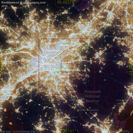
Analysis of Ramblewood night lights 2016
Square area 10x10 km:
 23.81%
90-99
23.3%80-89
14.12%70-79
21.09%60-69
14.97%50-59
2.72%40-49
0%30-39
0%20-29
0%10-19
0%0-9
0%Square area 50x50 km:
20.18%90-99
14.59%80-89
9.59%70-79
11.59%60-69
8.62%50-59
5.35%40-49
5.34%30-39
3.94%20-29
3.26%10-19
6.8%0-9
10.74%Clear (daylight) street map image can be seen on geolist.org.
Map coordinates:
40° 27' 56.8" North, 75° 38' 48.9" West
39° 55' 43.4" North, 74° 56' 37.6" West
39° 23' 14.7" North, 74° 14' 26.4" West
Some cities around Ramblewood sort by population:
• Mount Laurel
4.5 km =2.8 mi,  82°
82°
• Maple Shade
4.9 km =3 mi,  302°
302°
• Springdale
3.5 km =2.2 mi,  213°
213°
• Moorestown-Lenola
4.5 km =2.8 mi,  336°
336°
• Cherry Hill Mall
5.6 km =3.5 mi,  278°
278°
• Greentree
3.7 km =2.3 mi,  196°
196°
• Marlton
4.6 km =2.9 mi,  155°
155°
• Kingston Estates
3.8 km =2.4 mi,  261°
261°
4503736 (p: 5,907)
Sources (retrieved 2019-11-25):
» Earth at Night: Flat Maps 2012, 2016