Moorestown-Lenola night lights from space
Night Light of Moorestown-Lenola (New Jersey) from space (United States) Src. Average luminocity for 10x10km area is 86.6837% and for 50x50km: 70.355%.
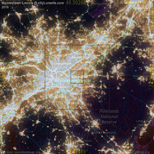
Analysis of Moorestown-Lenola night lights 2016
Square area 10x10 km:
 21.09%
90-99
25.85%80-89
20.75%70-79
21.6%60-69
10.71%50-59
0%40-49
0%30-39
0%20-29
0%10-19
0%0-9
0%Square area 50x50 km:
21.95%90-99
15.84%80-89
10.46%70-79
12.71%60-69
10.7%50-59
5.63%40-49
4.61%30-39
3.15%20-29
2.53%10-19
5.6%0-9
6.84%Clear (daylight) street map image can be seen on geolist.org.
Map coordinates:
40° 30' 9.6" North, 75° 40' 3.1" West
39° 57' 57.3" North, 74° 57' 51.9" West
39° 25' 29.6" North, 74° 15' 40.6" West
Some cities around Moorestown-Lenola sort by population:
• Cherry Hill
6.6 km =4.1 mi,  238°
238°
• Maple Shade
2.8 km =1.7 mi, 238°
• Cinnaminson
4.2 km =2.6 mi,  324°
324°
• Springdale
7 km =4.3 mi,  181°
181°
• Cherry Hill Mall
5.1 km =3.2 mi,  228°
228°
• Palmyra
7.1 km =4.4 mi,  310°
310°
• Ramblewood
4.5 km =2.8 mi,  156°
156°
• Kingston Estates
5.1 km =3.2 mi,  203°
203°
7258303 (p: 14,217)
Sources (retrieved 2019-11-25):
» Earth at Night: Flat Maps 2012, 2016