Cherry Hill Mall night lights from space
Night Light of Cherry Hill Mall (New Jersey) from space (United States) Src. Average luminocity for 10x10km area is 95.3554% and for 50x50km: 72.7484%.
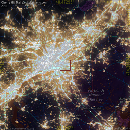
Analysis of Cherry Hill Mall night lights 2016
Square area 10x10 km:
 37.41%
90-99
43.54%80-89
13.61%70-79
5.27%60-69
0.17%50-59
0%40-49
0%30-39
0%20-29
0%10-19
0%0-9
0%Square area 50x50 km:
23.2%90-99
16.47%80-89
10.64%70-79
12.99%60-69
10.47%50-59
5.61%40-49
5.22%30-39
3.83%20-29
2.88%10-19
3.94%0-9
4.76%Clear (daylight) street map image can be seen on geolist.org.
Map coordinates:
40° 28' 22.6" North, 75° 42' 43.9" West
39° 56' 9.4" North, 75° 0' 32.6" West
39° 23' 40.9" North, 74° 18' 21.4" West
Some cities around Cherry Hill Mall sort by population:
• Pennsauken
4.7 km =2.9 mi,  298°
298°
• Maple Shade
2.3 km =1.4 mi,  37°
37°
• Springdale
5.2 km =3.2 mi,  135°
135°
• Moorestown-Lenola
5.1 km =3.2 mi,  48°
48°
• Collingswood
5.7 km =3.5 mi,  249°
249°
• Haddonfield
5.5 km =3.4 mi,  206°
206°
• Ramblewood
5.6 km =3.5 mi,  98°
98°
• Kingston Estates
2.3 km =1.4 mi,  127°
127°
4501204 (p: 14,171)
Sources (retrieved 2019-11-25):
» Earth at Night: Flat Maps 2012, 2016