Nuevo Progreso night lights from space
Night Light of Nuevo Progreso (Tamaulipas) from space (Mexico) Src. Average luminocity for 10x10km area is 22.9345% and for 50x50km: 30.7579%.
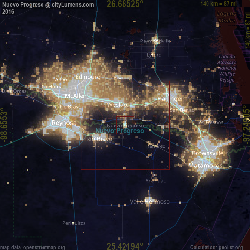
Analysis of Nuevo Progreso night lights 2016
Square area 10x10 km:
 0.4%
0.4%90-99
1.98%80-89
2.78%70-79
4.37%60-69
2.38%50-59
3.77%40-49
4.56%30-39
5.56%20-29
7.54%10-19
25.6%0-9
41.07%Square area 50x50 km:
3.52%90-99
3.82%80-89
5.57%70-79
4.07%60-69
7.51%50-59
6.1%40-49
4.95%30-39
4.65%20-29
6.56%10-19
10.79%0-9
42.48%Clear (daylight) street map image can be seen on geolist.org.
Map coordinates:
26° 41' 6.9" North, 98° 39' 19.1" West
26° 3' 19.1" North, 97° 57' 7.8" West
25° 25' 19" North, 97° 14' 56.6" West
Some cities around Nuevo Progreso sort by population:
• Ciudad Río Bravo
16.1 km =10 mi,  241°
241°
• Weslaco, US
12.2 km =7.6 mi,  341°
341°
• Alamo, US
22.2 km =13.8 mi,  309°
309°
• Mercedes, US
11.2 km =7 mi,  20°
20°
• Donna, US
16.2 km =10.1 mi,  322°
322°
• La Feria, US
17.2 km =10.7 mi,  48°
48°
• Mila Doce, US
19 km =11.8 mi,  357°
357°
• Progreso, US
4.1 km =2.5 mi,  353°
353°
3522525 (p: 10,178)
Sources (retrieved 2019-11-25):
» Earth at Night: Flat Maps 2012, 2016