Prien night lights from space
Night Light of Prien (Louisiana) from space (United States) Src. Average luminocity for 10x10km area is 81.0472% and for 50x50km: 21.2326%.
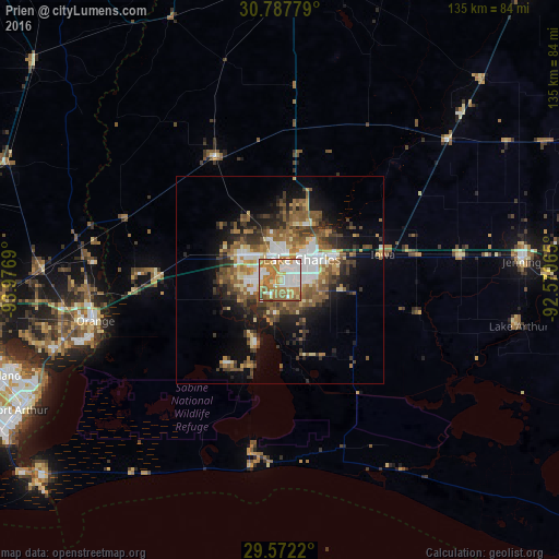
Analysis of Prien night lights 2016
Square area 10x10 km:
 21.85%
90-99
19.23%80-89
11.54%70-79
13.29%60-69
23.08%50-59
8.39%40-49
2.27%30-39
0.35%20-29
0%10-19
0%0-9
0%Square area 50x50 km:
3.15%90-99
3.06%80-89
2.53%70-79
2.56%60-69
3.76%50-59
5.01%40-49
3.21%30-39
3.83%20-29
4%10-19
8.8%0-9
60.08%Clear (daylight) street map image can be seen on geolist.org.
Map coordinates:
30° 47' 16" North, 93° 58' 36.8" West
30° 10' 54.7" North, 93° 16' 25.6" West
29° 34' 19.9" North, 92° 34' 14.3" West
Some cities around Prien sort by population:
• Lake Charles
7.5 km =4.7 mi,  62°
62°
• Sulphur
11.7 km =7.3 mi,  301°
301°
• Orange
45.6 km =28.3 mi,  257°
257°
• Groves
67.1 km =41.7 mi,  247°
247°
• Port Neches
69.2 km =43 mi, 252°
• Moss Bluff
15.6 km =9.7 mi,  30°
30°
• Jennings
59.4 km =36.9 mi,  85°
85°
• Bridge City
57.9 km =36 mi, 251°
4338068 (p: 7,810)
Sources (retrieved 2019-11-25):
» Earth at Night: Flat Maps 2012, 2016