Groves night lights from space
Night Light of Groves (Texas) from space (United States) Src. Average luminocity for 10x10km area is 82.786% and for 50x50km: 30.598%.
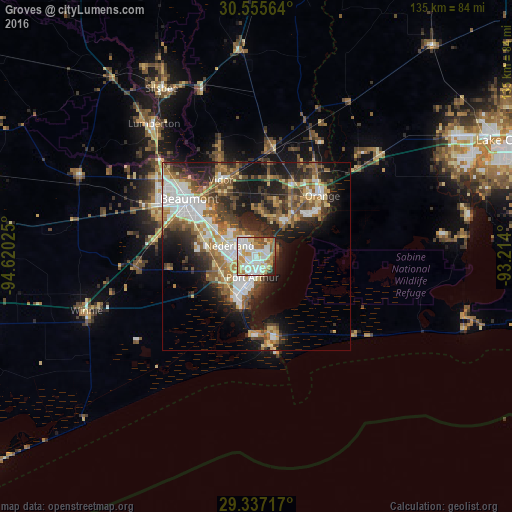
Analysis of Groves night lights 2016
Square area 10x10 km:
 24.05%
90-99
27.46%80-89
13.64%70-79
10.98%60-69
8.33%50-59
7.01%40-49
4.73%30-39
1.33%20-29
2.46%10-19
0%0-9
0%Square area 50x50 km:
5.86%90-99
5.23%80-89
3.99%70-79
3.08%60-69
4.88%50-59
5.06%40-49
4.53%30-39
5.01%20-29
7.94%10-19
13.39%0-9
41.03%Clear (daylight) street map image can be seen on geolist.org.
Map coordinates:
30° 33' 20.3" North, 94° 37' 12.9" West
29° 56' 53.8" North, 93° 55' 1.6" West
29° 20' 13.8" North, 93° 12' 50.4" West
Some cities around Groves sort by population:
• Beaumont
23.5 km =14.6 mi,  310°
310°
• Port Arthur
7.4 km =4.6 mi,  199°
199°
• Orange
23.7 km =14.7 mi,  47°
47°
• Nederland
7.8 km =4.8 mi,  291°
291°
• Port Neches
6.2 km =3.9 mi,  320°
320°
• Lumberton
44.6 km =27.7 mi, 322°
• Vidor
22.5 km =14 mi,  335°
335°
• Bridge City
10.6 km =6.6 mi,  40°
40°
4695317 (p: 15,750)
Sources (retrieved 2019-11-25):
» Earth at Night: Flat Maps 2012, 2016