Pound Ridge night lights from space
Night Light of Pound Ridge (New York) from space (United States) Src. Average luminocity for 10x10km area is 4.8393% and for 50x50km: 31.2263%.
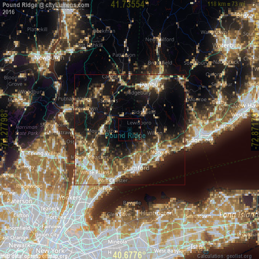
Analysis of Pound Ridge night lights 2016
Square area 10x10 km:
 0%
0%90-99
0%80-89
0%70-79
0.32%60-69
0%50-59
1.3%40-49
1.14%30-39
0.32%20-29
4.87%10-19
4.22%0-9
87.82%Square area 50x50 km:
3.26%90-99
3.86%80-89
3.98%70-79
5.06%60-69
5.91%50-59
5.75%40-49
5.3%30-39
5.65%20-29
8.43%10-19
19.34%0-9
33.47%Clear (daylight) street map image can be seen on geolist.org.
Map coordinates:
41° 44' 7.9" North, 74° 16' 40.7" West
41° 12' 31.4" North, 73° 34' 29.5" West
40° 40' 39.4" North, 72° 52' 18.2" West
Some cities around Pound Ridge sort by population:
• North Stamford
8.3 km =5.2 mi,  161°
161°
• Norwalk
17.3 km =10.7 mi,  125°
125°
• Darien
16.9 km =10.5 mi,  148°
148°
• New Canaan
9.6 km =6 mi,  135°
135°
• Wilton
11.6 km =7.2 mi,  97°
97°
• North Castle
11.9 km =7.4 mi,  230°
230°
• Mount Kisco
12.7 km =7.9 mi,  267°
267°
• Ridgefield
10.3 km =6.4 mi,  38°
38°
5132152 (p: 5,104)
Sources (retrieved 2019-11-25):
» Earth at Night: Flat Maps 2012, 2016