Plymouth night lights from space
Night Light of Plymouth (Massachusetts) from space (United States) Src. Average luminocity for 10x10km area is 36.2127% and for 50x50km: 14.2997%.
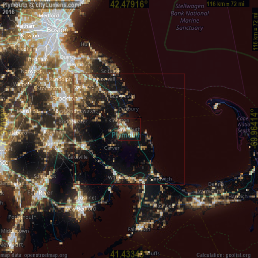
Analysis of Plymouth night lights 2016
Square area 10x10 km:
 5.71%
5.71%90-99
5.08%80-89
4.13%70-79
4.76%60-69
5.71%50-59
7.46%40-49
4.92%30-39
2.7%20-29
9.52%10-19
30.79%0-9
19.21%Square area 50x50 km:
1.06%90-99
1.49%80-89
1.57%70-79
1.47%60-69
2.2%50-59
3.18%40-49
2.77%30-39
2.93%20-29
4.38%10-19
13.03%0-9
65.92%Clear (daylight) street map image can be seen on geolist.org.
Map coordinates:
42° 28' 45" North, 71° 22' 13.4" West
41° 57' 30.4" North, 70° 40' 2.1" West
41° 26' 0.3" North, 69° 57' 50.9" West
Some cities around Plymouth sort by population:
• Middleborough
21.4 km =13.3 mi,  250°
250°
• Hanover
20.9 km =13 mi,  325°
325°
• East Bridgewater
25.5 km =15.8 mi,  289°
289°
• Kingston
6.2 km =3.9 mi,  310°
310°
• Carver
11.5 km =7.1 mi,  223°
223°
• Norwell
24.9 km =15.5 mi,  335°
335°
• Halifax
16.5 km =10.3 mi,  282°
282°
• Middleborough Center
22.6 km =14 mi, 251°
4947597 (p: 7,494)
Sources (retrieved 2019-11-25):
» Earth at Night: Flat Maps 2012, 2016