Halifax night lights from space
Night Light of Halifax (Massachusetts) from space (United States) Src. Average luminocity for 10x10km area is 14.6492% and for 50x50km: 29.8852%.
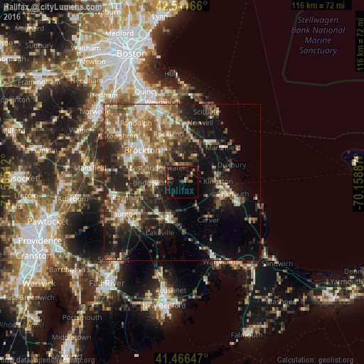
Analysis of Halifax night lights 2016
Square area 10x10 km:
 0%
0%90-99
0.16%80-89
1.75%70-79
0.79%60-69
3.17%50-59
1.9%40-49
2.7%30-39
2.7%20-29
4.44%10-19
28.1%0-9
54.29%Square area 50x50 km:
3.07%90-99
4.42%80-89
3.49%70-79
3.26%60-69
5.48%50-59
6.93%40-49
5.65%30-39
5.37%20-29
9.44%10-19
15.63%0-9
37.26%Clear (daylight) street map image can be seen on geolist.org.
Map coordinates:
42° 30' 42" North, 71° 33' 54.4" West
41° 59' 28.4" North, 70° 51' 43.2" West
41° 27' 59.3" North, 70° 9' 31.9" West
Some cities around Halifax sort by population:
• Middleborough
11.6 km =7.2 mi,  200°
200°
• Hanover
14.2 km =8.8 mi,  16°
16°
• Whitman
11.7 km =7.3 mi,  328°
328°
• East Bridgewater
9.3 km =5.8 mi,  300°
300°
• Kingston
11.4 km =7.1 mi,  88°
88°
• Bridgewater
9.3 km =5.8 mi,  269°
269°
• Middleborough Center
12 km =7.5 mi,  206°
206°
• West Bridgewater
12.4 km =7.7 mi,  284°
284°
4938652 (p: 7,631)
Sources (retrieved 2019-11-25):
» Earth at Night: Flat Maps 2012, 2016