Kingston night lights from space
Night Light of Kingston (Massachusetts) from space (United States) Src. Average luminocity for 10x10km area is 31.2603% and for 50x50km: 19.2183%.
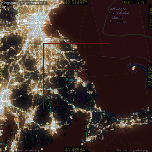
Analysis of Kingston night lights 2016
Square area 10x10 km:
 3.33%
3.33%90-99
3.33%80-89
5.08%70-79
1.9%60-69
7.3%50-59
3.81%40-49
5.71%30-39
3.02%20-29
10.48%10-19
33.49%0-9
22.54%Square area 50x50 km:
1.77%90-99
2.42%80-89
2.22%70-79
2.21%60-69
3.37%50-59
4.03%40-49
3.87%30-39
3.66%20-29
5.81%10-19
12.78%0-9
57.86%Clear (daylight) street map image can be seen on geolist.org.
Map coordinates:
42° 30' 53.9" North, 71° 25' 39.4" West
41° 59' 40.4" North, 70° 43' 28.1" West
41° 28' 11.4" North, 70° 1' 16.9" West
Some cities around Kingston sort by population:
• Middleborough
19.1 km =11.9 mi,  233°
233°
• Hanover
15 km =9.3 mi,  331°
331°
• Whitman
19.9 km =12.4 mi,  298°
298°
• East Bridgewater
19.9 km =12.4 mi,  282°
282°
• Carver
12.7 km =7.9 mi,  194°
194°
• Norwell
19.5 km =12.1 mi,  342°
342°
• Halifax
11.4 km =7.1 mi,  268°
268°
• Plymouth
6.2 km =3.9 mi,  130°
130°
4941383 (p: 12,208)
Sources (retrieved 2019-11-25):
» Earth at Night: Flat Maps 2012, 2016