Oak Hills night lights from space
Night Light of Oak Hills (California) from space (United States) Src. Average luminocity for 10x10km area is 36.9103% and for 50x50km: 20.5373%.
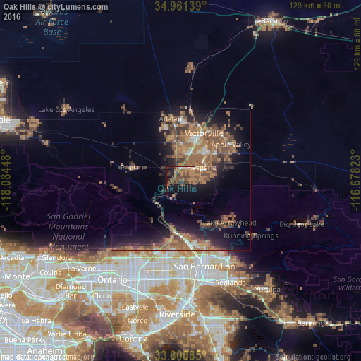
Analysis of Oak Hills night lights 2016
Square area 10x10 km:
 0.92%
0.92%90-99
1.47%80-89
0.37%70-79
6.59%60-69
14.29%50-59
10.07%40-49
13.74%30-39
7.33%20-29
6.04%10-19
26.74%0-9
12.45%Square area 50x50 km:
1.07%90-99
1.52%80-89
0.73%70-79
2.23%60-69
7.9%50-59
6.03%40-49
5.15%30-39
3.44%20-29
5.06%10-19
11.07%0-9
55.8%Clear (daylight) street map image can be seen on geolist.org.
Map coordinates:
34° 57' 41" North, 118° 5' 4.1" West
34° 22' 59.3" North, 117° 22' 52.9" West
33° 48' 3.1" North, 116° 40' 41.6" West
Some cities around Oak Hills sort by population:
• Victorville
18.9 km =11.7 mi,  25°
25°
• Hesperia
8.8 km =5.5 mi,  56°
56°
• Apple Valley
22.2 km =13.8 mi,  53°
53°
• Adelanto
22.3 km =13.9 mi,  353°
353°
• Phelan
18.2 km =11.3 mi,  285°
285°
• Lake Arrowhead
23.2 km =14.4 mi,  130°
130°
• Crestline
18 km =11.2 mi,  150°
150°
• Spring Valley Lake
16.1 km =10 mi,  40°
40°
5378354 (p: 8,879)
Sources (retrieved 2019-11-25):
» Earth at Night: Flat Maps 2012, 2016