Pine Island Ridge night lights from space
Night Light of Pine Island Ridge (Florida) from space (United States) Src. Average luminocity for 10x10km area is 95.2738% and for 50x50km: 60.0545%.
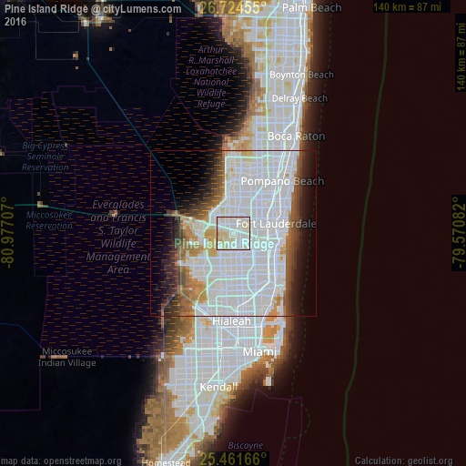
Analysis of Pine Island Ridge night lights 2016
Square area 10x10 km:
 33.33%
90-99
47.02%80-89
18.06%70-79
1.59%60-69
0%50-59
0%40-49
0%30-39
0%20-29
0%10-19
0%0-9
0%Square area 50x50 km:
32.03%90-99
13.67%80-89
3.07%70-79
2.83%60-69
4.03%50-59
3.36%40-49
3.88%30-39
4.29%20-29
4.25%10-19
6.21%0-9
22.38%Clear (daylight) street map image can be seen on geolist.org.
Map coordinates:
26° 43' 28.4" North, 80° 58' 37.5" West
26° 5' 41.3" North, 80° 16' 26.2" West
25° 27' 42" North, 79° 34' 15" West
Some cities around Pine Island Ridge sort by population:
• Davie
5.4 km =3.4 mi,  131°
131°
• Plantation
6.1 km =3.8 mi,  43°
43°
• Lauderhill
7.9 km =4.9 mi,  50°
50°
• Cooper City
4.2 km =2.6 mi,  176°
176°
• Lauderdale Lakes
10.3 km =6.4 mi, 39°
• Southwest Ranches
7.5 km =4.7 mi,  237°
237°
• Melrose Park
8.3 km =5.2 mi,  75°
75°
• Broadview Park
6.5 km =4 mi,  85°
85°
4168506 (p: 5,218)
Sources (retrieved 2019-11-25):
» Earth at Night: Flat Maps 2012, 2016