Montgomeryville night lights from space
Night Light of Montgomeryville (Pennsylvania) from space (United States) Src. Average luminocity for 10x10km area is 77.1364% and for 50x50km: 51.9078%.
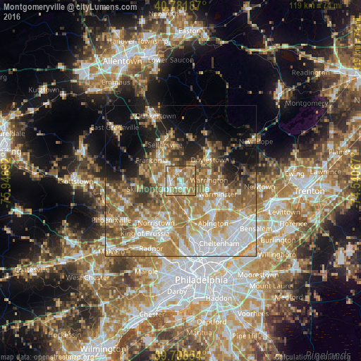
Analysis of Montgomeryville night lights 2016
Square area 10x10 km:
 12.66%
90-99
17.05%80-89
14.77%70-79
12.5%60-69
31.98%50-59
8.6%40-49
1.79%30-39
0.65%20-29
0%10-19
0%0-9
0%Square area 50x50 km:
10.25%90-99
9%80-89
7.02%70-79
9.38%60-69
12.45%50-59
8.97%40-49
5.29%30-39
4.69%20-29
5.09%10-19
8.55%0-9
19.3%Clear (daylight) street map image can be seen on geolist.org.
Map coordinates:
40° 46' 54.7" North, 75° 56' 48.9" West
40° 14' 50.4" North, 75° 14' 37.6" West
39° 42' 30.7" North, 74° 32' 26.4" West
Some cities around Montgomeryville sort by population:
• Lansdale
3.5 km =2.2 mi,  259°
259°
• Doylestown
11.9 km =7.4 mi,  54°
54°
• Kulpsville
7.9 km =4.9 mi,  266°
266°
• Souderton
10 km =6.2 mi,  316°
316°
• Maple Glen
9.3 km =5.8 mi,  144°
144°
• Ambler
10.5 km =6.5 mi,  169°
169°
• Blue Bell
10.7 km =6.6 mi,  190°
190°
• Fort Washington
12.1 km =7.5 mi, 165°
5201776 (p: 12,624)
Sources (retrieved 2019-11-25):
» Earth at Night: Flat Maps 2012, 2016