Gettysburg night lights from space
Night Light of Gettysburg (Pennsylvania) from space (United States) Src. Average luminocity for 10x10km area is 27.7381% and for 50x50km: 9.8262%.
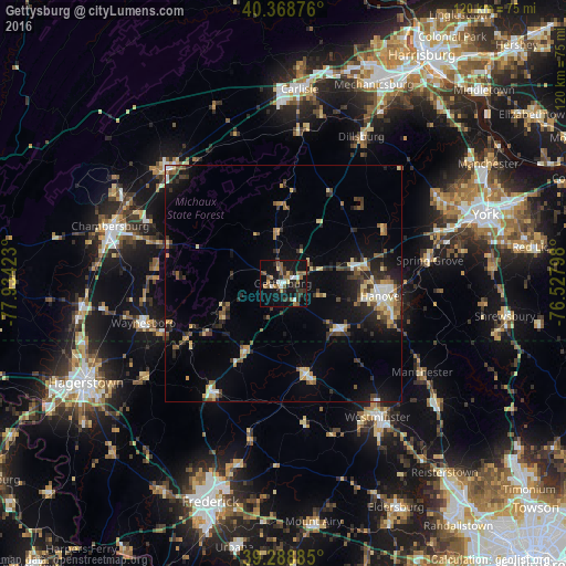
Analysis of Gettysburg night lights 2016
Square area 10x10 km:
 3.06%
3.06%90-99
3.06%80-89
1.36%70-79
1.7%60-69
5.78%50-59
8.16%40-49
3.06%30-39
6.97%20-29
5.44%10-19
33.5%0-9
27.89%Square area 50x50 km:
0.76%90-99
1.01%80-89
1.6%70-79
0.91%60-69
1.3%50-59
1.4%40-49
1.53%30-39
1.95%20-29
2.46%10-19
6.15%0-9
80.95%Clear (daylight) street map image can be seen on geolist.org.
Map coordinates:
40° 22' 7.5" North, 77° 56' 3.2" West
39° 49' 51.3" North, 77° 13' 52" West
39° 17' 19.9" North, 76° 31' 40.7" West
Some cities around Gettysburg sort by population:
• Chambersburg
38.6 km =24 mi,  287°
287°
• Westminster
34.8 km =21.6 mi,  144°
144°
• Hanover
21.5 km =13.4 mi,  99°
99°
• Waynesboro
30.8 km =19.1 mi,  254°
254°
• Taneytown
19.8 km =12.3 mi,  165°
165°
• Parkville
23.5 km =14.6 mi, 103°
• Thurmont
27.7 km =17.2 mi,  213°
213°
• Shippensburg
34.7 km =21.6 mi,  314°
314°
4558183 (p: 7,608)
Sources (retrieved 2019-11-25):
» Earth at Night: Flat Maps 2012, 2016